
Tracing a North Las Vegas Street
A North Las Vegas street directory is an address-keyed trail, not a list of every household. The address first leads to an Assessor parcel, then the parcel number can connect the map, tax information, legal description, and recorded documents. That sequence can establish title and a dated ownership trail. It cannot, by itself, establish every current occupant. Preserve the exact address, APN, and date for each step so that similar street names, changed postal labels, and nearby parcels do not get merged.
USPS can verify a mailing form and ZIP, but it expressly does not confirm who occupies an address. The Assessor distinguishes the situs address from the tax mailing address. A Recorder document identifies parties to that document, not everyone at the location. Voter records and reverse directories add limited context only when they are lawfully available and match the date being researched.
- Verify the address with USPS ZIP Code Lookup, retaining the returned city and ZIP as mailing information rather than occupancy proof.
- Search the Clark County Assessor by address and save the APN, situs, owner, mailing address, subdivision, lot or block, and document link.
- Select the parcel in Clark County OpenWeb to compare adjacent parcels, ownership rows, legal description, tax district, and street context.
- Use the Recorder parcel search and owner name to locate the latest deed or trust deed, matching the APN and legal description.
- For an earlier address period, use the closest regional criss-cross directory, full directory, obituary, probate, or library source and mark gaps honestly.
North Las Vegas Street Directory Fields
The Clark County Assessor lists address, owner name, parcel number, subdivision, parcel type or book and page, parcel tree, parcel map, recorded documents, and building sketches as real-property search modes. For an address query, enter the street number and street name in the format recognized by the portal. When a match fails, test the directional prefix, suffix, spelling, postal label, and the APN. North Las Vegas and Las Vegas labels can cross ZIP and municipal boundaries, so the name of the postal city is not enough.
| Assessor address control | Street-directory use |
|---|---|
| Street number and street name | Primary address path; test formatting variations when the search misses. |
| City or postal label | Optional context only, because city and ZIP boundaries do not always align. |
| APN | Alternative key when a street address is ambiguous, altered, or incomplete. |
| Owner name | Alternative path; last name is required in owner mode, with an optional first name and phonetic matching. |
| Mailing and situs fields | Result values that must be preserved separately, not treated as the same address. |
The official Assessor real-property search displays the address, owner, parcel, and map routes.
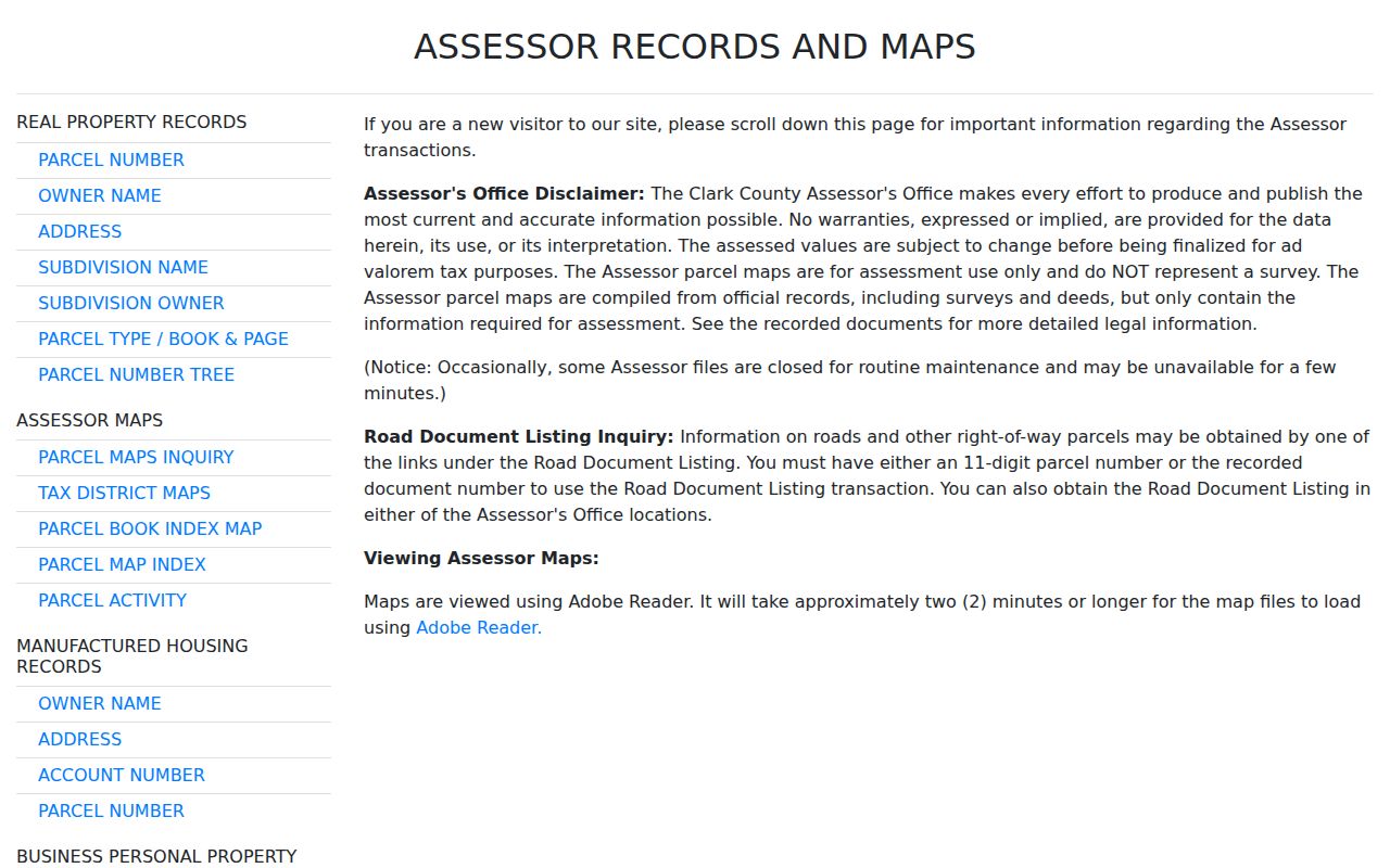
The resulting parcel record makes the APN, location address, ownership clue, legal description, and recorded-document link available for the next stage.
North Las Vegas Streets in OpenWeb
OpenWeb supplies the map side of the street directory. Pan to a street segment and use Select Property to open a parcel. Property Information can show the site address, owner, sale data where available, construction year, recorded document number, and aerial date. Its Ownership table can show current and prior recorded rows, vesting, tax district, and estimated size. The Legal Description panel adds subdivision, book or page, lot or block, township-range-section, tax district, and census tract.
Map layers and panels add zoning, planned land use, flood, jurisdiction, and elected-district context. OpenWeb also has print, export, and measure tools. The GIS disclaimer matters: its maps are reference information, not a survey. A measurement or line on the viewer should not replace a recorded plat, legal description, or survey when the distinction matters.
The Clark County OpenWeb viewer is the official map interface for parcel-by-parcel inspection.
Clicking adjoining parcels one at a time is the reliable way to compare a block; no verified official tool publishes a complete nearby-household list.
- APN
- The assessor parcel number, a county identifier that connects parcel, tax, and many document searches.
- Situs address
- The physical location address of the parcel, which can differ from the mailing address used for tax notices.
- Plat
- A recorded subdivision or parcel map showing lot, block, boundary, and related recording information.
- Criss-cross directory
- A historic reverse directory arranged from address to an occupant clue rather than from name to address.
North Las Vegas Address Components
North Las Vegas uses a number, directional prefix, primary street name, and suffix. The city addressing ordinance describes valley blocks of roughly 528 feet. This is a practical research detail: losing a directional prefix, using a different suffix, or relying on an older postal-city label can make the same parcel look like a failed address search. Preserve each component exactly as found in the source.
When a historic entry conflicts with a current street string, compare the current number, directional, street, suffix, ZIP, city, APN, subdivision, and legal description. A changed postal city does not necessarily show a move. A changed APN can reflect a split, replat, or parcel-number update. The city addressing authority and county GIS office are the appropriate custodians for a question that the web lookup cannot resolve.
Note: A street address is delivery and location information; the APN and legal description are the better bridge across changing address formats.
North Las Vegas Street Record Layers
Address records serve different roles in a North Las Vegas street directory. The parcel card is the place-to-owner starting point. OpenWeb shows the selected parcel’s map and contextual panels. The Recorder gives the documents behind a transfer or lien. City permit records can show a project connection, but an applicant or contractor is not necessarily an occupant. Election information is governed by its own statutes and protected-voter rules. Reading the sources as a chain is more reliable than making a conclusion from one search result.
| Address-keyed record | North Las Vegas keeper | Useful connection | Access channel |
|---|---|---|---|
| Parcel card and tax statement | Clark County Assessor and Treasurer | APN, owner, situs and mailing values, parcel history | Free portal; tax search has separate situs and mailing modes |
| OpenWeb parcel map | Clark County GIS | Parcel geometry, adjacent APNs, ownership rows, zoning and districts | Free browser viewer; reference-only, not a survey |
| Recorded documents | Clark County Recorder | Parties, instrument date, legal description, APN where included | Free summary index; online, mail, or counter copies |
| Election records | Clark County Election Department | Lawfully public registration and district information | Public service or separate file request, with statutory withholding |
| Permit and inspection records | North Las Vegas Development Services | Project address, applicant or contractor, inspection and certificate events where releasable | CSS account route or focused city request |
The APN is the durable bridge among these records. A street name can change format, a lot can be replatted, and a ZIP may cover a partial city area. Match the APN and legal description before carrying a name from an Assessor or Recorder result into a North Las Vegas street-directory conclusion.
North Las Vegas Deeds by Parcel
The Recorder is where an APN becomes a dated document trail. Parcel search accepts a parcel number with starts-with, contains, or exact operators, along with date-range and document-type controls. Recorder research coverage is described as 1909 to the present. Search the current owner as a grantee around the acquisition date, compare the APN and legal description, then identify the seller or prior instrument. Repeating that sequence backward builds a chain of title, meaning the documented transfers of the same parcel.
A deed record can identify grantor and grantee parties, instrument number, recording date, document type, book or page reference, APN or legal description where supplied, and a copy route. The online index is a summary. The Recorder says online images are not original records available for unrestricted web viewing. Copies are available online, by mail, or at the office. Keep the instrument number and page count for a mail or counter request.
The Clark County Recorder parcel search provides the APN, date-range, and document-type path.
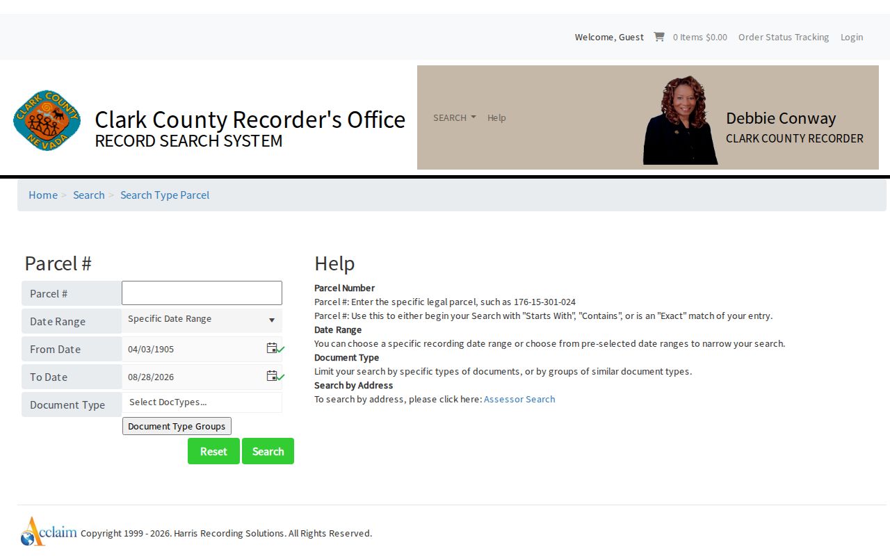
Matching the legal description matters because an address can be changed, missing, or associated with more than one parcel over time.
North Las Vegas Permits by Address
North Las Vegas Development Services is the city-side address record route. Its services include permits, inspections, business licenses, fire permits, public works, subdivision, parcel, planning, zoning, and mapping functions. The Permit Application Center lists building, plumbing, mechanical, electrical, fire-protection, early-addressing, fencing, tract-home, and related forms. CSS requires an account for many payment and status functions. A detailed research request should state the exact address and relevant date range.
When releasable, a permit may connect a project address with an applicant, contractor, submittal, inspection event, certificate request, or document history. Those are project links, not occupancy proof. Plans may require architect or engineer release under NAC 623.780. If a historical permit view appears empty, note that the city’s CSS update required earlier account holders to re-register after June 20, 2025, then ask Development Services whether the record is in an older system or needs a city public-record request.
North Las Vegas Voter Street Clues
Clark County Election Department is the election-record custodian. The public voter lookup and statistics entry point is not a street-by-street household directory. It may provide a public registration service and active totals, while a full voter file follows a separate request route. The research record does not establish a fixed public request form, fee, or delivery format, so ask the department for the current NRS 293.440 and NRS 293.558 requirements before requesting a file.
Nevada voter records carry strict limits. Core fields can be public, but Social Security numbers, driver-license or identification numbers, voter email, and approved address or telephone withholding remain protected. A result may identify a lawfully public registration connection, but it cannot identify all people on a street. It also should be cross-checked with a parcel, public document, obituary, or other dated source before a same-name record is attributed to the address.
Note: Clark County’s live registration statistics update hourly, while a township PDF is a dated snapshot and does not equal a North Las Vegas city total.
North Las Vegas Historical Street Clues
For a past North Las Vegas address, regional reverse directories are a useful but limited final layer. Official historic surveys identify Luskey’s Las Vegas Criss-Cross City Directory for 1956, 1957, 1959, 1966, and 1967, and document a full-directory review for 1943-44 when a cross-reference did not answer the question. Treat those sources as regional evidence, not proof of a continuous North Las Vegas series. City limits and postal labels can differ from a directory’s reach.
Start with the normalized address from the target year. Test directional prefixes, suffixes, numbered or spelled forms, and likely postal labels. Record the address entry, household clue, page, abbreviation key, and directory year. Then search the name portion, compare spouse or other distinguishing details, and pair the result with an Assessor parcel, Recorder document, census, obituary, probate item, or permit. The North Las Vegas directory book identifies the library and archive routes for this historic layer.
North Las Vegas Street Directory Limits
A North Las Vegas street directory cannot show a complete household at an address. Property records describe ownership, title, assessment, and mailing information. The public record sources reviewed do not create an official list of all people at a parcel. DMV personal address data is restricted under the federal Driver’s Privacy Protection Act. Utility-customer information is not a public resident roll. A public voter result, where released, does not identify every household member and can be withheld for a protected voter.
Nevada’s Confidential Address Program gives qualifying victims a fictitious address and mail forwarding. A missing or substitute address can therefore be intentional and lawful. Sealed court files, confidential vital records, restricted law-enforcement material, and protected election information are not gaps to work around. Use the record that is lawfully public, then stop when the public trail ends.
Lawful personal research. North Las Vegas address records have limited public uses, but protected information remains protected. Do not use a street, parcel, or registry result to stalk, harass, intimidate, or harm anyone.